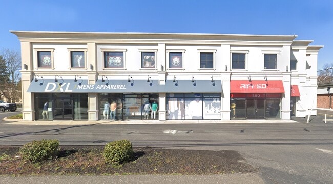
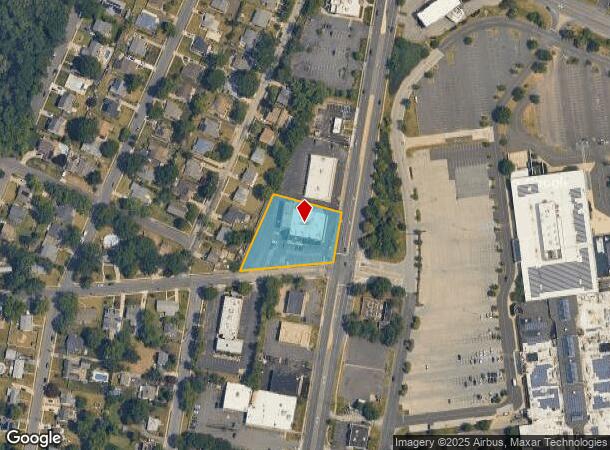
Property Record
226 Haddonfield Rd, Cherry Hill, NJ 08002
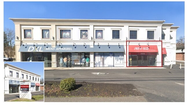

Current Lease Availabilities
NEARBY LISTINGS FOR SALE OR LEASE
Property Detail
226 Haddonfield Rd
Philadelphia-Camden-Wilmington, PA-NJ-DE-MD
Merchantville Terrace
09-00207-01-00003
INCL BLK 507-01 LOTS 3 & 4
Commercialnec
Camden
X
New Jersey
34005C0209F
3
2024
1.56 AC
2025
North Camden County
603201
Philadelphia
DEMOGRAPHICS near 226 Haddonfield Rd
1 Mile
3 Mile
5 Mile
2024 Total Population
13,799
126,637
308,761
2029 Population
14,036
127,018
310,130
Pop Growth 2024-2029
+ 1.72%
+ 0.30%
+ 0.44%
Average Age
41
40
40
2024 Total Households
5,534
48,852
118,376
HH Growth 2024-2029
+ 1.84%
+ 0.42%
+ 0.43%
Median Household Inc
$96,914
$84,688
$78,789
Avg Household Size
2.40
2.50
2.50
2024 Avg HH Vehicles
2.00
2.00
2.00
Median Home Value
$253,434
$246,607
$262,951
Median Year Built
1968
1959
1956
Nearby Places
- Restaurants
- Banks
- Shops
- Fitness
- Groceries
PUBLIC TRANSPORTATION
COMMUTER RAIL
Cherry Hill (Atlantic City Line - NJ Transit Commuter Rail (NJ Transit))
DRIVE
WALK
Distance
Cherry Hill (Atlantic City Line - NJ Transit Commuter Rail (NJ Transit))
6 min
3.1 mi
Pennsauken Transit Center (Atlantic City Rail Line - NJ TRANSIT RAIL)
DRIVE
WALK
Distance
Pennsauken Transit Center (Atlantic City Rail Line - NJ TRANSIT RAIL)
8 min
3.6 mi
AIRPORT
Philadelphia International
DRIVE
WALK
Distance
Philadelphia International
28 min
16.4 mi
Trenton Mercer
DRIVE
WALK
Distance
Trenton Mercer
49 min
34.2 mi
Freight Ports
Port of Philadelphia
DRIVE
WALK
Distance
Port of Philadelphia
13 min
8.0 mi
Nearby Properties
Address
Land Use
TOTAL SIZE
Lot Size
Zoning
Address
Land Use
TOTAL SIZE
Lot Size
Zoning
66.02 AC
Address
Land Use
TOTAL SIZE
Lot Size
Zoning
Address
Land Use
TOTAL SIZE
Lot Size
Zoning
90.41 AC
Address
Land Use
TOTAL SIZE
Lot Size
Zoning
20.13 AC
Address
Land Use
TOTAL SIZE
Lot Size
Zoning
49.16 AC
Address
Land Use
TOTAL SIZE
Lot Size
Zoning
54.54 AC
Address
Land Use
TOTAL SIZE
Lot Size
Zoning
10,292 SF
21.30 AC
Address
Land Use
TOTAL SIZE
Lot Size
Zoning
8.50 AC
Address
Land Use
TOTAL SIZE
Lot Size
Zoning
1 SF
42.23 AC
Address
Land Use
TOTAL SIZE
Lot Size
Zoning
37.60 AC
Address
Land Use
TOTAL SIZE
Lot Size
Zoning
Address
Land Use
TOTAL SIZE
Lot Size
Zoning
12.80 AC
R20
Address
Land Use
TOTAL SIZE
Lot Size
Zoning
17.62 AC
Address
Land Use
TOTAL SIZE
Lot Size
Zoning
Address
Land Use
TOTAL SIZE
Lot Size
Zoning
27.83 AC
Address
Land Use
TOTAL SIZE
Lot Size
Zoning
Address
Land Use
TOTAL SIZE
Lot Size
Zoning
6.30 AC
Address
Land Use
TOTAL SIZE
Lot Size
Zoning
32.46 AC
Address
Land Use
TOTAL SIZE
Lot Size
Zoning
5.35 AC
Address
Land Use
TOTAL SIZE
Lot Size
Zoning
Address
Land Use
TOTAL SIZE
Lot Size
Zoning
28.96 AC
Address
Land Use
TOTAL SIZE
Lot Size
Zoning
4.93 AC
Address
Land Use
TOTAL SIZE
Lot Size
Zoning
Address
Land Use
TOTAL SIZE
Lot Size
Zoning
8.85 AC
Address
Land Use
TOTAL SIZE
Lot Size
Zoning
22.45 AC
MD
Address
Land Use
TOTAL SIZE
Lot Size
Zoning
37.39 AC
Address
Land Use
TOTAL SIZE
Lot Size
Zoning
Address
Land Use
TOTAL SIZE
Lot Size
Zoning
9.27 AC
Address
Land Use
TOTAL SIZE
Lot Size
Zoning
35.57 AC
Address
Land Use
TOTAL SIZE
Lot Size
Zoning
The World's #1 Commercial Real Estate Marketplace
Connect with us
© 2025 CoStar Group
The information above has been obtained from sources believed reliable. While we do not doubt its accuracy we have not verified it and make no guarantee, warranty or representation about it. It is your responsibility to independently confirm its accuracy and completeness. Any projections, opinions, assumptions, or estimates used are for example only and do not represent the current or future performance of the property. The value of this transaction to you depends on tax and other factors which should be evaluated by your tax, financial, and legal advisors. You and your advisors should conduct a careful, independent investigation of the property to determine to your satisfaction the suitability of the property for your needs.